|
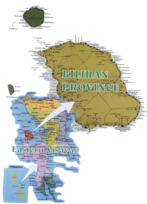
Biliran is one of the smallest provinces in the Philippines and it is located in the Eastern Visayas region. An island province,
Biliran lies just a few kilometers north of the island of Leyte. Its capital is Naval and for a time, Biliran was part of
the province of Leyte until it became independent in 1992.
Demographics
Based on the May 2000 census, Biliran has a total population of 140,274, which makes it the fifth least populous province
in the country, and the smallest in the region. There are 27,907 households in the province with an average size of 5.02 persons,
slightly higher than the national average of 4.99.
Languages
The inhabitants of Biliran primarily speak Cebuano and Waray. Cebuano, spoken by 57.79% of the population is found mainly
on the western area of the island, nearest Cebu, while Waray-Waray spoken by 40.80% can be found on the eastern portion. Majority
of the residents also speak and understand Tagalog and English.
Economy
The economy of Biliran is largely into fishing. Most of its towns, especially Naval and Biliran, have excellent seaports.
There are 95 hectares of brackish water fishponds which produce prawns, shrimps and milkfish. Another 30 hectares of seawater
are suitable for seaweed farming and 10 more hectares for fishcage culture.
Being mountainous, Biliran can support various agricultural crops. The warm lowlands are conducive to palay production
and other tropical crops. The cool highlands are favorable to high-value crops such as cutflowers and varieties of vegetable
traditionally grown in Baguio City or Tagaytay City.
The inhabitants also engage in hunting, lumber, and manufacturing. The principal raw material produced is copra and coconut
oil. Processed goods include white clay ceramics, dried fish, raw gulaman, and citronella oil.
The untapped natural resources of the island include geothermal power and the abundant sulfur and gypsum deposits.
Political
Biliran is subdivided into 8 municipalities. All the municipalities except Maripipi are located on Biliran Island while
Maripipi is an island municipality located to the northwest. The largest is Naval, the capital. The smallest is Maripipi.
Municipalities
* Almeria
* Biliran
* Cabucgayan
* Caibiran
* Culaba
* Kawayan
* Maripipi
* Naval
Physical
Biliran has a total land area of 555.4 square kilometers, making it the fourth smallest province in the Philippines. The
two major islands are Biliran Island and Maripipi Island.
Biliran Island lies off the northern coast of Leyte across Biliran Strait. To the southeast is Carigara Bay, to the northeast
is Samar Sea, and further on, the island of Samar. To the west is the Visayan Sea and Masbate lies 30 km to the northwest.
The main island is mountainous with very narrow coastal areas. Only the municipalities of Naval and Caibiran have wide
plains suitable for agriculture. Mount Suiro, which has an elevation of 1,300 meters is the highest point on the island.
History
During the early Spanish era, what is now called Biliran Island was known as Isla de Panamao. The term refers to an ethnic
fishing net. The present name, believed to be adopted sometime between the late 1600s and the early 1700s, was, according
to many publications, derived from a native grass called borobiliran which once grew abundantly on the island's plains. A
contending theory states that the name came from the word bilir, which was defined in an old Visayan dictionary to be the
"corner or edge of a boat, vase or anything protruding, like veins, or the furrow made by the plow." The dictionary
also gives biliran as an alternate spelling for bilir. This theory is supported by the fact that Biliran was site of the first
large-scale shipyard, built in the 1600s. Galleons were built to support the Galleon Trade between Manila and Acapulco in
Mexico.
The first town, named Biliran, was founded in 1712. During this time, the island was a part of the province of Cebu. Biliran,
together with the islands of Samar and Leyte were constituted into a separate province in 1735. Later when Samar and Leyte
were split into two provinces in 1768, Biliran became part of Leyte.
During the World War II, Biliran had its own guerilla forces under the Leyte command of Colonel Ruperto Kangleon. The
guerrilla operation where of invaluable assistance to the successful landing of the American liberation forces at Palo, Leyte,
on October 20, 1944 just before the Battle of Leyte Gulf.
On April 8, 1959 Republic Act No. 2141 was signed into law effectively making Biliran a sub-province of Leyte. The island
was only made an independent province on May 11, 1992 by virtue of Republic Act No. 7160, making it one of the newest provinces
in the country.
|
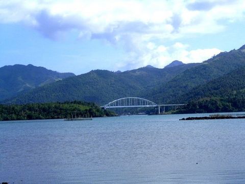
| The bridge connecting Biliran Province to Leyte Province as viewed from the pier of Biliran town |
Wikipedia: Biliran
|